EMC technologies based on digital area maps
For more than 15 years, EMC R&D laboratory develops the software for frequency planning and intersystem EMC analysis in space-scattered ground-based complexes of wireless systems. This software is based on radio-wave propagation modeling which takes into account the frequency and polarization of radiation in the ranges of meter, decimeter, and centimeter waves (VHF, UHF, SHF, etc.). With the help of digital area maps and GIS platforms (such as GIS, Panorama, MapInfo, etc.), topographical heterogeneity of the terrain and vegetation are taken into account by the use of models given in ITU-R Recommendations.
Software is developed with a glance of customers requirements.
Software is shipped to customers of Belarus, Russia, and other countries.
Software NFPS is an example of the program utilizing GIS technology.
 |
 |
Main technical characteristics:
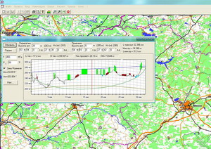
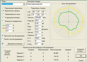
- Radio-wave propagation modeling taking into account topographic and electric heterogeneity of terrain, frequency and polarization of emission, and vegetation, including urban-area propagation scenarios.
- Calculation of basic losses, levels of radio signals, signal-to-interference ratios, coverage, responsibility, and interference zones of radio transmitters.
- Handover boundary estimation based on signal power or on signal-to-interference ratio.
- Designing radio relay lines, visualization of propagation paths between any pairs of points on the terrain with indication of line-of-sight areas and shadowing of paths by topographic obstacles; representation of coverage zones and interference zones on the map in the form of conventional symbols (map legend).
- Multimode and multi-scale color graphic representation of geographic digital area map, two-dimensional representation of electromagnetic field level within the radio transmitter?s coverage/interference zone;
- Map navigation with calculation of true geographic coordinates, absolute altitudes, distances between objects, true and magnetic azimuths of directions to arbitrary objects, representation of names and characteristic features for populated areas and hydrographic objects;
- Intrasystem EMC analysis and simulation/modeling for space-scattered radio communication networks;
- Frequency plan optimization for radio networks with the use of efficient genetic algorithms of discrete optimization
Files to download:
2. "NFPS" Flyer
3. "NFPS & Hop Designer" Presentation